
Welcome to Shenandoah National Park
Welcome to the Shenandoah National Park Information Page.
Here you will find all you need to know about the natural history of the park.
Learn about the geology, trees, mammals, birds, or other plants and wildlife of the area.
Shenandoah National Park is located in northwestern Virginia, northwest of Charlottesville, Virginia. The Park is approximately 75 miles west of Washington, DC and the Headquarters office is located 3.0 miles west of Thornton Gap and 4.0 miles east of Luray, Virginia on U.S. 211.
Getting Here
The closest major airports are in Washington, DC (90 miles), Charlottesville (50 miles) and Weyers Cave (45 miles), Virginia.
Additional Directions
Since there are no bus, taxi or shuttle services through the Park, a car is needed. Accessible by I-66 and Highway 340 South to the north entrance at Front Royal, Highway 211 for the central entrance at Thornton Gap, Highway 33 at Swift Run Gap and I-64 at the Rockfish Gap entrance. Speed limit for the Skyline Drive is 35mph.
Transportation
There is No bus or train services. Taxi service is available from Front Royal, Luray and Waynesboro to areas in the Park. From Front Royal to the first visitor center, Dickey Ridge, is 5 miles, to Skyland is 42 miles. From Luray to Thornton Gap Entrance Station is 9 miles, to Skyland, 19 miles and to Big Meadows, 29 miles. From Waynesboro to the Loft Mountain area is 30 miles and to Big Meadows the distance is 60 miles.
Establishment
22 May 1926, Congress authorized the establishment of Shenandoah National Park. It became fully established on 26 December 1935
Size and Visitation
The total acreage is 196,466.19, including 79,579 acres of the designated wilderness area.
The highest visitation is during the fall color season and the summer months. Traffic can be heavy on Skyline Drive during these weekends.
History of Shenandoah National Park
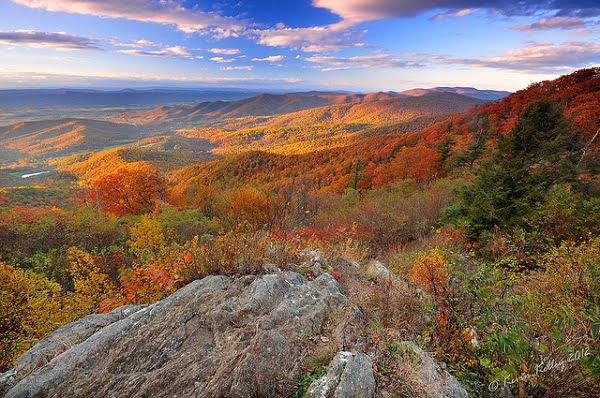
Shenandoah National Park lies astride a beautiful section of the Blue Ridge, which forms the eastern rampart of the Appalachian Mountains between Pennsylvania and Georgia. In the valley to the west is the Shenandoah River, from which some feel the Park gets its name, and between the north and south forks of the river is Massanutten, a 40 mile long mountain. To the east is the rolling Piedmont country. Providing vistas of the spectacular landscape is Skyline Drive, a winding road that runs along the crest of this portion of the Blue Ridge Mountains through the length of the Park.
Wilderness
Wilderness…the word has different meanings to different people, but here in Shenandoah National Park, wilderness is something special. Of the park’s nearly 196,000 acres 79,579 have been designated by Congress as wilderness. But what does this mean?
In 1964, the Congress of the United States passed a law known as the Wilderness Act, which created a National Wilderness Preservation System to provide an “enduring resource of wilderness” for future generations. President Lyndon Johnson signed the Wilderness Act into law on September 3, 1964. Today, over 100 million acres across the country are protected as wilderness.
Wilderness, according to the Wilderness Act, “…in contrast with those areas where man and his own works dominate the landscape, is hereby recognized as an area where the earth and its community of life are untrammeled by man, where man himself is a visitor who does not remain.” The Wilderness Act goes on to describe wilderness as a place “retaining its primeval character and influence” where there are “outstanding opportunities for solitude”.
Accessibility
Most comfort stations and buildings are accessible or accessible with help. Overnight accommodations are available at Lewis Mountain, Skyland and Big Meadows Lodge.
The trail circles through an old-growth forest of magnificent hemlocks and includes a 65 foot bridge and 150 foot boardwalk.
Basic Recommendations
I recommend that you plan your trip and the areas you would like to see and then go and relax and make a day of it. Go and see all that is in the area and enjoy it. You spend more quality time and learn and see more than you could ever imagine.
Shenandoah National Park lies astride a beautiful section of the Blue Ridge, which forms the eastern rampart of the Appalachian Mountains between Pennsylvania and Georgia. In the valley to the west is the Shenandoah River, from which some feel the Park gets its name, and between the north and south forks of the river is Massanutten, a 40-mile-long mountain. To the east is the rolling Piedmont country. Providing vistas of the spectacular landscape is Skyline Drive, a winding road that runs along the crest of this portion of the Blue Ridge Mountains through the length of the Park.
Backcountry Camping Most of Shenandoah National Park, including its wilderness, is open to backcountry camping. Special regulations for backcountry camping are intended to keep campers and the park in the best possible condition. A free permit is required for backcountry camping. Permits are available by mail from Park Headquarters.
Biking
Bicycling is permitted along Skyline Drive and on paved areas in the park, but nowhere else. (The park is preserving the natural world, so no off-road riding of any kind is permitted on trails, fire roads, or grassy open areas.) Because Skyline Drive is a two-lane road with steep hills and many blind curves, park officials do not encourage bicycling, especially for children.
Commercial Tour Fees
A commercial tour is defined as consisting of “one or more persons traveling on an itinerary that has been packaged, priced or sold for leisure or recreational purposes by an organization that realizes financial gain through the provision of the services.”
Entrance fees are based upon the total capacity of the vehicles that can carry seven or more passengers. Possession of a national park passport or the age of the passengers does not affect the price charged. Entrance fees are valid for the day of purchase and the next six days for a vehicle carrying the same group of passengers.
Fishing
A Virginia fishing license is required for those between 16 and 65.
Food and Supplies
Waysides
Elkwallow at Mile 24.1
Big Meadows at Milepost 51
Loft Mountain at Mile 79.5
Campstores
Elkwallow at Mile 24.1
Big Meadows at Milepost 51
Lewis Mountain at Mile 57.6
Loft Mountain at Mile 79.5
Capacity Fees:
1-6 Passengers: $ 25.00+ ($ 25.00 + $5.00 per passenger)
7-15 passenger capacity $ 75.00
16-25 passenger capacity $ 100.00
26+ passenger capacity $ 200.00
Hiking
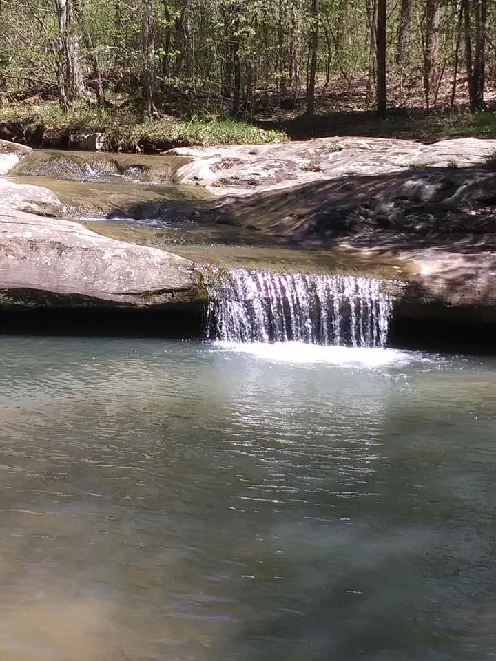
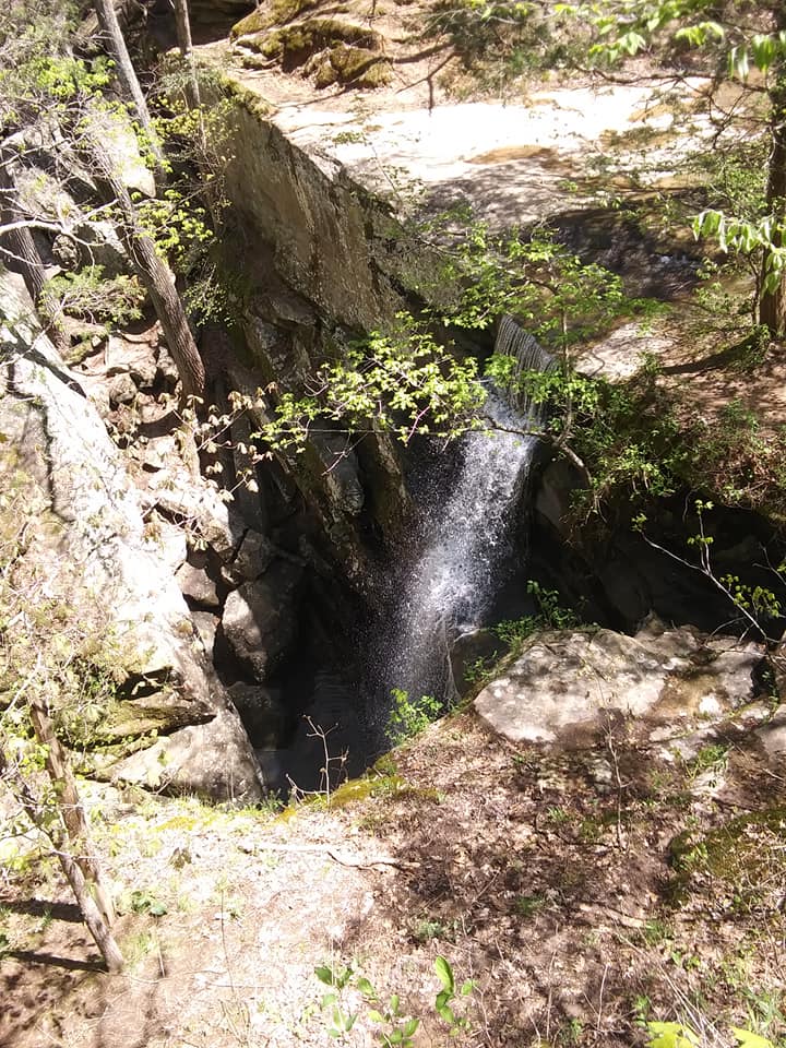
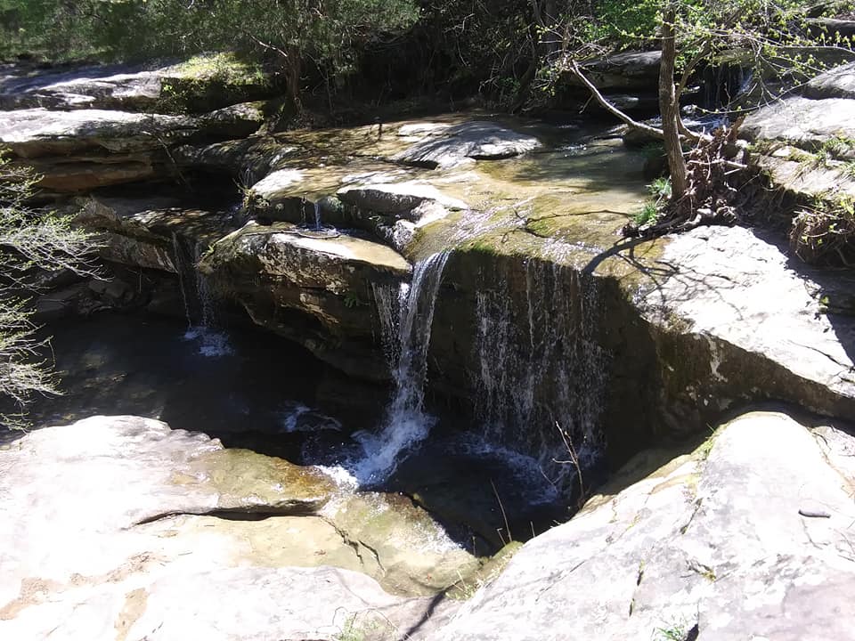
There are over 500 miles of hiking trails in Shenandoah National Park. The trails vary in length from short-stretchers to a 101 mile segment of the Appalachian Trail that runs the length of the park. Many of the trailheads are located on Skyline Drive and in the developed areas. The Whiteoak Canyon Trail leads to six waterfalls and an old-growth forest.
To know more you visit Hiking Page
Horseback Riding
There are more than 150 miles of horse trails in the park. Visitors may bring their own horses, or sign up for a guided trail ride from the Skyland Stables (May through October).
Horseback riding is available at Skyline, weather permitting. Riders must be at least 4 ft 10 in height. Pony rides are available for children.
Lodging
Lodges and Cabins in the park are:
Big Meadows Lodge
Lewis Mountain Cabins
Skyland Lodge
To know more you visit Lodging Page
Permits and Reservations
Most of Shenandoah National Park, including its wilderness, is open to backcountry camping. Special regulations for backcountry camping are intended to keep campers and the park in the best possible condition. A free permit is required for backcountry camping. Permits are available by mail from Park Headquarters.
Pet Information
Pet owners have the special responsibility of following park rules for pets. Pets must be on a leash at all times in the park. Pets are allowed in campgrounds, but not in lodging units. Your pet is allowed on most trails, if he/she is on a 6-foot lead. But a few trails are rocky, or designed for family groups; and one trail is ADA accessible. For the protection of the park and the safety of others, a few trails, listed here from north to south, are not open to pets:
- Fox Hollow Nature Trail (mile 4.6)
- Stony Man Nature Trail (mile 41.7)
- Limberlost Trail (milepost 43)
- Old Rag Ridge Trail
- Old Rag Saddle Trail (above Old Rag Shelter)
- Dark Hollow Falls Trail (mile 50.7)
- Story of the Forest Nature Trail (milepost 51)
- Bearfence Mountain Trail (mile 56.4)
- Frazier Discovery Trail (mile 79.5)
- Even though it may appear long, this list totals fewer than 20 miles of the 500 miles of trails in the park!
Picnic Areas
There are seven picnic areas. Tables, fireplaces, drinking fountains and restrooms are provided.
Ticks
Protect yourself against ticks.
As you walk through foothill grasses, a tick may hitch a ride. Tick bites are painless, but a small percentage of ticks carry Lyme disease. If you have been hiking in brushy or grassy areas, check yourself thoroughly when you return from your hike. Use tick repellent on all clothing, including footwear, according to label instructions. Be careful if you bring your pet dog along because they may easily latch onto them. You could carry a dog-friendly tick repellant so that you may be able to repel and prevent tick bites as much as possible. Bathe your dogs once back home so that all ticks and fleas may be washed off and prevented from entering your home. Tuck shirts into pants and pants into socks. If you find a tick, remove it with tweezers and seek a ranger’s or doctor’s advice. Wash the area thoroughly with soap and water.
Visitor Centers
Dickey Ridge Visitor Center
Harry F. Byrd, Sr. Visitor Center
Loft Mountain Information Center
Weather of Shenandoah National Park
The mountains in Shenandoah National Park are usually 10 degrees cooler than the valley below. Winters can be severe with snow and ice and summer showers are the usual. Layered clothing is always suggested.
To know more you visit Weather Page